Federal agencies have teamed up to conduct detailed surface and subsurface mapping of a large swath of western Nevada, a project aimed at revealing sites with a high potential for geothermal energy or lithium.
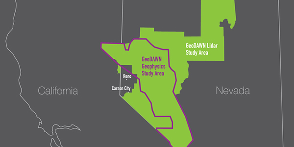
The U.S. Geological Survey and the Department of Energy in September announced the project, called Geoscience Data Acquisition for Western Nevada (GeoDAWN). The study will use light detection and ranging, or lidar, for surface mapping of the area, and geophysical techniques, including aeromagnetic surveys, to look beneath the surface.
DOE officials said last week that the $10 million project is well underway, with completion expected next year. The data will be made public when the project is finished.
The project area includes a roughly 200-mile-long piece of the Walker Lane geologic area, a fault system that runs near the Nevada-California border. The GeoDAWN area also extends into a portion of central Nevada and up to a section of the state’s northern border.
The GeoDAWN area has a high potential for discovery of new geothermal energy resources, according to USGS. The study will also look for spots with large amounts of critical minerals including lithium, which is needed for lithium-ion batteries such as those used in electric cars.
The project will reduce the risk for companies interested in geothermal exploration, said Susan Hamm, geothermal technologies office director in DOE’s Office of Energy Efficiency and Renewable Energy. The project could potentially lead to the establishment of new geothermal energy plants within the next decade, she said.
“It’s going to generate many exciting leads,” Hamm told NetZero Insider.
Finding geothermal clues
GeoDAWN will combine a number of techniques to look for geothermal potential and minerals. In addition to lidar and aeromagnetic surveys, the project will use airborne radiometry and geochemical analysis of rock and brine samples.
Lidar involves bouncing laser beams off the surface of the Earth from an aircraft and measuring how quickly the light returns. The data can be used to produce highly detailed maps of the Earth’s surface.
Magnetic surveys, also conducted from an aircraft, detect small changes in magnetic fields and can spot underground features such as faults.
Many geothermal resources are hidden or “blind,” meaning there’s no surface feature such as a hot spring to show where they are, Hamm said.
Fault patterns are one indicator of where a geothermal resource might lie. Researchers are still discovering what other features are associated with a geothermal resource.
The study will also examine areas where geothermal resources have already been found, for example, during mining operations. Machine-learning will be used to look for the features of those areas at other sites.
“It couldn’t be more exciting,” Hamm said.
Building on Past Work
The project will build on past research on geothermal resources in Nevada.
Researchers from the Nevada Bureau of Mines and Geology previously combined several sets of geologic and geophysical data for a large area in central Nevada. The data included characteristics of surface faults and measurements of gravity and temperature gradients.
The study led to the creation of a geothermal potential map, pointing researchers to two previously undiscovered, blind geothermal systems. At one of those sites, in Gabbs Valley, temperatures of 255 degrees Fahrenheit were found at a depth of 500 feet.
NBMG Director James Faulds said information acquired through the GeoDAWN project will be an important addition to data used in the earlier study. NBMG, which is housed at the University of Nevada, Reno, serves as the geological survey for the state and has provided technical assistance to the project.
New geothermal hot spots may be discovered through GeoDAWN, and the project’s findings will help rate promising geothermal sites already identified, Faulds told NetZero Insider.
GeoDAWN will also help Nevada catch up on lidar data collection. Up until recently, only 6% of the state had been covered by high-resolution lidar, the lowest percentage of any state, according to Faulds. GeoDAWN will bring that figure up to around 31%, he said, with other projects adding about another 9%.
The USGS 3D Elevation Program (3DEP) is working to achieve nationwide lidar coverage by 2023. Faulds said 3DEP has provided matching funds to others interested in lidar projects, such as local water authorities, but that hasn’t been much help for the vast amount of federal land in Nevada. Faulds said he encouraged federal agencies to talk to each other about ways to get more lidar coverage for the state.
In addition to USGS and the DOE Office of Energy Efficiency and Renewable Energy, partners in GeoDAWN include the Bureau of Land Management and the U.S. Department of Agriculture’s Natural Resources Conservation Service.
Mapping Lithium Potential
Nevada lags in lidar data acquisition despite having what may be the most geothermal potential among the 50 states, based on its geology, Faulds said. The state is second only to California in the production of geothermal energy.
Nevada also stands out in terms of lithium potential.
The U.S. is heavily dependent on imports to meet its lithium needs, according to USGS, and currently the only domestic source of lithium is in Nevada.
In contrast to geothermal resources, no one has made a map of lithium potential in the state, Faulds said.
“That is … badly needed to better evaluate where some of those sort of hidden and additional lithium resources might be,” he said.