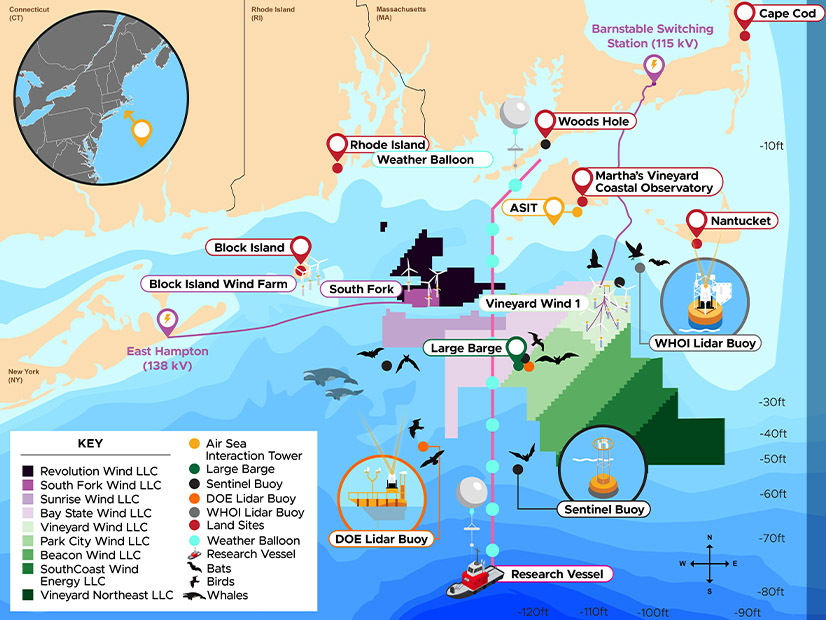
Researchers have activated a new array of sensors off the New England coast to gather information that could improve the design and operation of wind energy generators.
The equipment was set up over the past three months and on Feb. 15 began gathering data on wind and weather patterns as well as wildlife activity.
The zone being monitored — south of Massachusetts and Rhode Island, east of Long Island — is a center of early offshore wind energy development in the United States. A small wind farm has been operating there since 2016, three larger facilities are under construction and plans for six lease areas there are in various stages of development.
The efficiency of those wind farms will benefit from analysis of the wind and weather, and of the interaction between the ocean and atmosphere, the U.S. Department of Energy and the National Oceanic and Atmospheric Administration said Feb. 15.
Seven surface buoys, two subsurface buoys and six shoreline field stations have been set up, along with three lidar buoys that can measure wind up to 250 meters above sea level. The Woods Hole Oceanographic Institution’s air-sea interaction tower near Nantucket will be used as well.
Along with weather, the sensors will monitor the activities of birds, bats and whales over the next 18 months. Researchers hope to gain a better understanding of their patterns of movement in the area, and thereby analyze the effects of offshore wind construction and operation on wildlife.
The effort is called WFIP3 — it is the third phase of the Wind Forecast Improvement Project funded by DOE and NOAA. The Pacific Northwest National Laboratory and Woods Hole are leading the weather component of WFIP3; Duke University is leading the wildlife component.
DOE and NOAA said the first and second phases collected data to improve the accuracy of short-term land-based wind forecasting/modeling in the Great Plains and Pacific Northwest regions, respectively.
The data generated by WFIP3 will be used to inform offshore wind generation siting and grid integration, as well as to advance weather and wind plant modeling.
Dave Turner, manager of NOAA’s Atmospheric Science for Renewable Energy Program, said in a news release: “We want to use these insights to improve NOAA’s operational weather prediction models, which often serve as the foundational forecasts for the energy community in their daily management of their wind plants.”
DOE’s Alejandro Moreno said: “Understanding the offshore environment better is a Grand Challenge that DOE and its partners are addressing to ensure that offshore wind can not only operate efficiently and sustainably, but also contribute to grid reliability in the energy system of the future.”


