A new report by the University of Hawaii Community Design Center explores the idea of creating “living” shorelines to fight sea level rise in Oahu’s urban and tourism core.
Authored by University of Hawaii professor Judith Stilgenbauer and funded by the state’s Office of Planning, the report focuses on the South Shore of Oahu, from Diamond Head through Waikiki and Honolulu, all the way to the Honolulu International Airport and Pearl Harbor.
The report explains that a sea level rise of 3.2 feet would flood 9,400 acres of land, displacing 13,300 residents and swamping 3,880 structures and nearly 18 miles of major roads. It would amount to “over $12.9 billion in economic loss and uncalculated number of billions of dollars in critical infrastructure loss.”
In addition to submerging sections of the shoreline, a 3.2-foot sea level rise, would increase the risk of flooding from tsunamis and hurricanes enough to put the entire urban core at risk. A 6-foot rise (assumed in the report to be reached by 2100) would put many of Waikiki’s famous beaches and hotels — and portions of Honolulu’s airport and central business district — underwater.
The project report explores a multifaceted approach to mitigate this risk: creating a living shoreline, adapting infrastructure to sea level rise and performing a “managed retreat” to higher elevations when necessary.
Much of Oahu’s South shoreline has been modified, with coastal wetlands filled to expand the airport, create harbors and extend land for public use and private construction. The report recommends reversing this development and creating a living shoreline, defined as “wetlands, tidal marshes and other vegetated coastal buffers that rely on ecosystem services and increase the distance between water and development, retain and absorb inundation, slow erosion and provide habitat.”
The value of a living shoreline would not only be its resilience to the evolving effects of rising sea level, but also in providing opportunity for “improved waterfront access, non-automobile circulation, recreation, culture, placemaking and education,” in addition to “traditional and productive Hawaii-specific biocultural land-water practices where possible and appropriate.”
Adapting infrastructure and conducting a managed retreat are simpler affairs, at least conceptually. For adaptation, the report recommends a combination of elevating structures, “floodable” development (structures designed for an occasional influx of water), and floating development. Suggestions conjure science fiction imagery: “floating buildings, transportation elements and infrastructure; elements are designed with fluctuating water levels in mind.”
Managed retreat would be a “withdrawal of development from the shoreline over time through managed abandonment of areas subject to frequent inundation.”
‘Catalytic’ Sites
In order to explore proof-of-concept, the report devised five criteria to help identify valuable areas: areas affected by a 3-foot sea level rise and exacerbated by tsunami or hurricane events; areas that could regularly be affected by a six-foot rise by 2100; properties large enough to avoid causing too many ownership conflict issues; tax parcels that have been affected by the previous criteria; and areas that would be affected by a 3-foot sea level rise by 2050.
The report identified three areas as “catalytic” sites: Ala Wai Canal in Waikiki, Ke’ehi Lagoon near the airport and the surrounding areas of the Pearl Harbor Visitor Center and Aiea Bay Recreation Area.
Perhaps the most important catalytic site would be the Ala Wai Canal, which runs from mountain streams behind Waikiki to the ocean. Long known as a polluted waterway with runoff from rivers and human trash dumping, its reach from the east side of Waikiki around the back of the area creates a pincer-like danger from rising sea level. The report cites a 2015 US Army Corps of Engineers study saying that damages associated with a 100-year flood event in the canal’s watershed are estimated at $1.14 billion.
Bordering the canal on one side is an 18-hole golf course, a park and canoe launching site, a public library and an elementary school; on the other side, the three-lane Ala Wai Boulevard and an additional lane for parking. The proof-of-concept design would reduce the golf course to nine holes and, over time, eliminate it completely, changing the entire site into a mixed-use area of an amphibious habitat, wetlands and urban agriculture. It would also, over the long term, eliminate automobile use of Ala Wai Boulevard and convert it for “multimodal transit, as well as improved pedestrian and bicycle connectivity and water access — all while providing flood-control for Waikiki (Ala Wai side), facilitating the elevation of critical infrastructure elements and, more generally, the adjacent urban fabric’s phased adaptation to increasing climate-crisis threats over time.”
The entire site would include walking paths, raised viewing platforms, water access and public facilities for recreation. The canal would use natural methods to keep the water clean, such as oysters, which are known to filter water and aid in water health. The Gowanus Canal in Brooklyn, New York, for example, is one of the most polluted waterways in the U.S., but programs such as the Billion Oyster Project are using this idea to help clean the polluted water.
Catalytic sites 2 and 3 — Ke’ehi Lagoon to the east of the airport and the Pearl Harbor Visitor Center and surroundings, respectively — would commit to many of the same practices: slowly changing the shoreline into coastal wetlands using native plant species and building public facilities to engage with the area and provide water access.
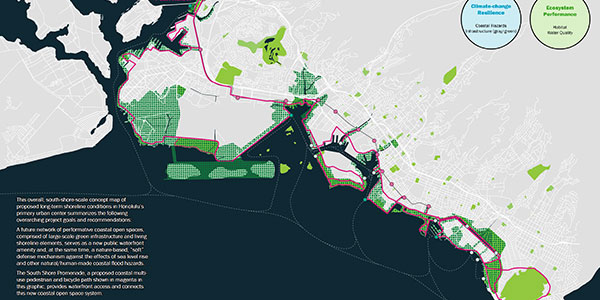
The report recommends connecting these three catalytic sites with the rest of the urban core via multimodal transit. Dubbed the South Shore Promenade, it would be a bicycle and pedestrian path along the urban core’s entire waterfront. This path would coincide with stations of the Honolulu Area Rapid Transit (HART), a raised rail transit system currently under construction.
The report also recommends the creation of a water taxi and ferry system with stations linked to the promenade to further reduce reliance on cars. This plan would help the traffic-jammed streets and highways of Honolulu, which for years has been rated one of the worst cities in the nation for traffic.