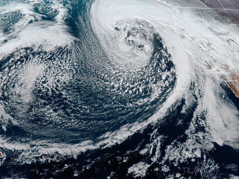
A series of Pacific storms are beginning to fill the lakes behind hydroelectric dams and to build snowpack for spring and summer generation, but California will continue to be gripped by drought without far more precipitation, officials said.
“It’s always great to be above average this early in the season, but we must be resilient and remember what happened last year,” Sean de Guzman, the state Department of Water Resource’s supply forecasting manager, said in a news release. “If January through March of 2023 turn out to be similar to last year, we would still end the water year in severe drought with only half of an average year’s snowpack.
“We still have a long way to go before the critical April 1 total,” de Guzman said. Months of heavy snow and rain will be needed to reach a historical average on that key date, the department said.
The latest storm was forecast to hit the state from Wednesday evening into Thursday, with heavy snow and rain and winds gusting to 60 mph or more.
“A powerful hurricane-force low pressure system located over the eastern Pacific is set to surge a plume of moisture and damaging winds into the West Coast beginning tonight,” the National Weather Service said on its website Wednesday. “The greatest impacts, which include damaging winds, excessive rainfall, and extremely heavy snow, is forecast to occur over much of California and into southern Oregon through Thursday.”
The ground remains saturated from a New Year’s Day deluge with strong winds that caused flash flooding, toppled trees and knocked out power to about 680,000 customers in the territories of Pacific Gas and Electric and the Sacramento Municipal Utility District.
The next storm could fell even more trees, the weather service warned.
“Be prepared for widespread power outages, downed trees and very difficult driving conditions,” it said on Twitter.
Atmospheric river weather systems, which bring large amounts of moisture from the central Pacific, could continue over the next two weeks due to a “persistent mid-level low pressure anchored over the North Pacific,” it said.
While the storms wreak havoc, they also bring much-needed water and snow to California, which has had three dry years in a row. With a Mediterranean climate, the state gets almost all its precipitation from December through February.
On Tuesday, the first snowpack measurement of the year showed it to be far above average in the north-central Sierra Nevada.
The Department of Water Resources (DWR) measured 55.5 inches of snow and a snow water equivalent of 17.5 inches — or 177% of average — at a main survey site in the mountains above Lake Tahoe.
“The snow water equivalent measures the amount of water contained in the snowpack and is a key component of DWR’s water supply forecast,” it said.
Statewide the snowpack was 174% of average for Jan. 3 and 64% of the average total for April, it said.
However, it warned that this year could see a repeat of last winter when a wet December was followed by three dry months.
“Conditions so far this season have proven to be strikingly similar to last year when California saw some early rainstorms and strong December snow totals only to have the driest January through March on record,” DWR said.
The state’s major hydroelectric reservoirs are filling from the rains but some of the biggest lakes remain far below capacity, DWR said. Low water levels have hurt hydropower, adding to the state’s summer resource shortfalls.
Lake Oroville, which ran so dry that generation ceased in July 2021, stood at 39% of capacity on Tuesday and held 74% of its historical average total for this time of year. Lake Shasta was at 34% capacity and 57% of its historical average.
Others had filled past their historical averages. Folsom Lake near Sacramento filled to 141% of its average for the date and was releasing large amounts of water from the New Year’s storm. The reservoir, however, is about one-fifth the size of Lake Oroville and one-fourth the size of Shasta.
If above-normal rainfall continues into spring, it would extend the state’s recent pattern of multiple drought years followed by one year of heavy precipitation. The pattern is a product of climate change, the state’s top water official said in the news release.
“The significant Sierra snowpack is good news, but unfortunately these same storms are bringing flooding to parts of California,” said DWR Director Karla Nemeth. “This is a prime example of the threat of extreme flooding during a prolonged drought as California experiences more swings between wet and dry periods brought on by our changing climate.”
