MISO does not foresee a scenario where it comes close to risky operations this winter, saying even a 107-GW demand peak should be manageable without emergency protocols.
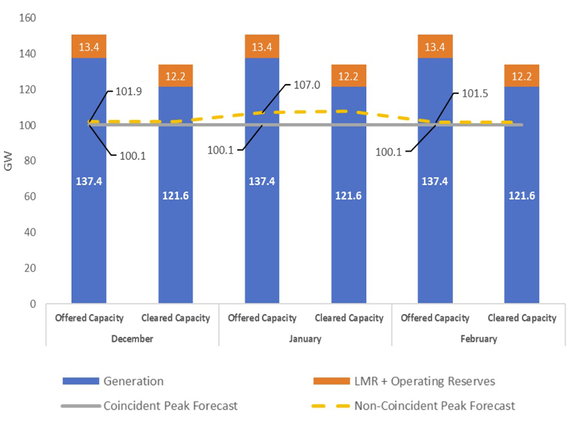
The grid operator published its annual winter outlook this week, predicting a nearly 21-GW excess in cleared capacity December through February using a coincident peak forecast and normal generation outages. Beyond its traditional supply, MISO has about 12 GW in load-modifying resources and operating reserves to lean on.
At a Nov. 14 workshop to discuss results, resource adequacy engineer John DiBasilio said that though MISO’s capacity auction cleared 121.6 GW of traditional generation for the winter, offers totaled 137.4 GW.
Across the board, MISO’s load-serving entities predict a 100.1-GW coincident peak; however, LSEs’ non-coincident peak predictions are 101.9 GW in December, 107 GW in January and 101.5 GW in February. Should a 107-GW peak occur in January, the RTO still predicts a 14.6-GW surplus among its nonemergency supply.
In a press release, Executive Director of Market Operations J.T. Smith credited MISO’s relatively new seasonal capacity auction for better preparing the footprint.
Last winter, MISO managed a 106-GW peak Jan. 17 during a wide-reaching cold spell without resorting to emergency procedures. (See MISO Holds Steady in Mid-Jan. Storm with Help from Wind.) MISO experienced its 109-GW all-time winter demand record on Jan. 6, 2017.
Part of MISO’s anticipated capacity sufficiency this winter is also thanks to an anticipated warmer winter across the footprint.
Analytics company and weather forecaster DTN predicts above-normal temperatures for the season in MISO’s South and Central regions with slightly warmer or closer-to-normal temperatures in the North region. The RTO splits its Midwest region into the Central, which includes the Dakotas, Minnesota, Iowa and Montana, and the North, which includes Wisconsin, Michigan, Illinois, Indiana, Missouri and Kentucky.
The National Oceanic and Atmospheric Administration anticipates closer-to-normal temperatures for MISO Midwest and a winter that trends above normal in MISO South.
Both forecasting authorities call for above-normal precipitation in MISO Midwest, especially around the Great Lakes, and a drier season for MISO South. MISO said the expected below-normal precipitation should decrease generation icing risks across the South.
MISO’s in-house meteorologist, Brett Edwards, said the season will be similar to last winter, which saw “exceptionally warm” temperatures, except for the mid-January cold snap, and normal precipitation patterns. The grid operator said last year’s temperatures are not a reference point for the upcoming winter.
Edwards said the best chances for some frigid days in MISO Midwest come in December and February if a weaker La Niña prevails. If a moderate-to-strong La Niña occurs, warmer air is expected to spread farther north. Edwards said the climate pattern appears to be shaping up to be weaker. He said historically, “weaker La Niña events have generated some cold shots and heavier precipitation events for the Midwest.”
MISO meteorologist Adam Simkowski added that though the RTO is anticipating a warmer winter overall, it is not ruling out the possibility of a few frigid blasts that drive load up, even in the South. He said that an active storm pattern around the Great Lakes could increase generation icing risks.
The RTO also noted that if all goes well at FERC, it should have an agreement on emergency energy purchases in place with the Tennessee Valley Authority beginning Dec. 24. (See MISO and TVA Strike Emergency Energy Purchase Agreement, Request FERC OK.)


